![](/images/other/stat-length.png)
![Excursión Bici de montaña Le Claux - Le Bois Mary - Photo](https://media.geolcdn.com/t/1900/400/ext.pjpeg?maxdim=2&url=https%3A%2F%2Fstatic1.geolcdn.com%2Fsiteimages%2Fupload%2Ffiles%2F1524743154velo.jpg)
Le Bois Mary
sebcar
Usuario
![Longitud](/images/other/stat-length.png)
Longitud
12,3 km
![Altitud máxima](https://static1.geolcdn.com/siteimages/upload/files/1508320355ic_sort_altitude_max_24dp.png)
Altitud máxima
1184 m
![Desnivel positivo](https://static1.geolcdn.com/siteimages/upload/files/1508320355ic_sort_den_pos_24dp.png)
Desnivel positivo
237 m
![Km-Effort](/images/other/stat-length.png)
Km-Effort
15,5 km
![Altitud mínima](https://static1.geolcdn.com/siteimages/upload/files/1508320355ic_sort_altitude_min_24dp.png)
Altitud mínima
1035 m
![Desnivel negativo](https://static1.geolcdn.com/siteimages/upload/files/1508320355ic_sort_den_neg_24dp.png)
Desnivel negativo
237 m
![Boucle](https://static1.geolcdn.com/siteimages/upload/files/16400158638029165_repeat_loop_refresh_sync_direction_icon.png)
Boucle
Sí
Fecha de creación :
2018-08-09 11:05:32.831
Última modificación :
2018-08-09 11:08:38.695
![Bici de montaña](https://static1.geolcdn.com/sitytour/trail-icons/202.png)
1h01
Dificultad : Fácil
![Escanee este código QR para abrir la excursión en la aplicación SityTrail](https://capi.geolives.com/qq0zvz2zws4bq2lad0pu/sitytour/trails/2005892/qr.png?size=200)
Aplicación GPS de excursión GRATIS
A propósito
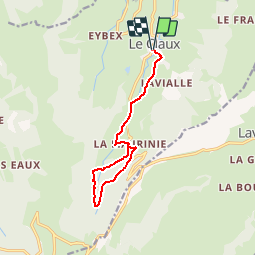
Ruta Bici de montaña de 12,3 km a descubrir en Auvergne-Rhône-Alpes, Cantal, Le Claux. Esta ruta ha sido propuesta por sebcar.
Descripción
Entre le Suc de la Blatte, le Bois Mary ce sentier offre une agréable randonnée au fond de la vallée de la Petite Rhue
Localización
País:
France
Región :
Auvergne-Rhône-Alpes
Departamento/provincia :
Cantal
Municipio :
Le Claux
Localidad:
Unknown
Salida:(Dec)
Salida:(UTM)
476879 ; 5000669 (31T) N.
Comentarios
Excursiones cerca
![Excursión Senderismo Lavigerie - Le Puy de Peyre Arse depuis la Gravière - Photo](https://media.geolcdn.com/t/375/260/ext.jpg?maxdim=2&url=https%3A%2F%2Fservices.sitytrail.com%2FGeolivesWS%2FDownloadMedia.ashx%3FTrailID%3D172317%26Media%3D13640_5.jpg)
![Senderismo Senderismo](https://static1.geolcdn.com/sitytour/trail-icons/101.png)
Le Puy de Peyre Arse depuis la Gravière
Senderismo
Difícil
(2)
Lavigerie,
Auvergne-Rhône-Alpes,
Cantal,
France
![](/images/other/stat-length.png)
11,2 km | 21 km-effort
4h 0min
![](https://static1.geolcdn.com/siteimages/upload/files/16400158638029165_repeat_loop_refresh_sync_direction_icon.png)
Sí
![Excursión A pie Le Claux - Les Chamois - Photo](https://media.geolcdn.com/t/375/260/510ea3bc-7b5b-4a87-873e-65c3812ffcb2.jpeg&format=jpg&maxdim=2)
![A pie A pie](https://static1.geolcdn.com/sitytour/trail-icons/100.png)
Les Chamois
A pie
Medio
Le Claux,
Auvergne-Rhône-Alpes,
Cantal,
France
![](/images/other/stat-length.png)
17,3 km | 25 km-effort
5h 36min
![](https://static1.geolcdn.com/siteimages/upload/files/16400158638029165_repeat_loop_refresh_sync_direction_icon.png)
No
![Excursión A pie Lavigerie - La Vallée de l'Impradine - Photo](https://media.geolcdn.com/t/375/260/5cfb4f36-6b62-4698-bb5b-742b53da1677.jpeg&format=jpg&maxdim=2)
![A pie A pie](https://static1.geolcdn.com/sitytour/trail-icons/100.png)
La Vallée de l'Impradine
A pie
Fácil
Lavigerie,
Auvergne-Rhône-Alpes,
Cantal,
France
![](/images/other/stat-length.png)
5,5 km | 7,6 km-effort
1h 44min
![](https://static1.geolcdn.com/siteimages/upload/files/16400158638029165_repeat_loop_refresh_sync_direction_icon.png)
Sí
![Excursión A pie Le Falgoux - Sentier de la cascade du Biaguin - Photo](https://media.geolcdn.com/t/375/260/9b956c23-a7e6-4fa5-9a0a-8ae63187caec.jpeg&format=jpg&maxdim=2)
![A pie A pie](https://static1.geolcdn.com/sitytour/trail-icons/100.png)
Sentier de la cascade du Biaguin
A pie
Fácil
Le Falgoux,
Auvergne-Rhône-Alpes,
Cantal,
France
![](/images/other/stat-length.png)
3,8 km | 5,5 km-effort
1h 14min
![](https://static1.geolcdn.com/siteimages/upload/files/16400158638029165_repeat_loop_refresh_sync_direction_icon.png)
Sí
![Excursión A pie Le Falgoux - La Baladie - Photo](https://media.geolcdn.com/t/375/260/9844acfe-57cd-4ed2-9915-09bb258bc9c1.jpeg&format=jpg&maxdim=2)
![A pie A pie](https://static1.geolcdn.com/sitytour/trail-icons/100.png)
La Baladie
A pie
Fácil
(1)
Le Falgoux,
Auvergne-Rhône-Alpes,
Cantal,
France
![](/images/other/stat-length.png)
10,9 km | 18,5 km-effort
4h 11min
![](https://static1.geolcdn.com/siteimages/upload/files/16400158638029165_repeat_loop_refresh_sync_direction_icon.png)
Sí
![Excursión Senderismo Lavigerie - Cantal - La Gravière - Les Fours de Peyre-Arse - 18.9km 760m 8h05 (30mn) - 2019 07 04 - Photo](https://media.geolcdn.com/t/375/260/9cfe2185-2c98-490a-a2cb-4203d8093887.jpg&format=jpg&maxdim=2)
![Senderismo Senderismo](https://static1.geolcdn.com/sitytour/trail-icons/101.png)
Cantal - La Gravière - Les Fours de Peyre-Arse - 18.9km 760m 8h05 (30mn) - 20...
Senderismo
Difícil
Lavigerie,
Auvergne-Rhône-Alpes,
Cantal,
France
![](/images/other/stat-length.png)
18,9 km | 29 km-effort
8h 5min
![](https://static1.geolcdn.com/siteimages/upload/files/16400158638029165_repeat_loop_refresh_sync_direction_icon.png)
Sí
![Excursión Senderismo Lavigerie - Cantal - La Gravière - La Vallée de l'Impradine - 6km 170m 2h20 - 2019 07 03 - Photo](https://media.geolcdn.com/t/375/260/ed622756-45b3-433e-a699-9a4285d0a037.jpg&format=jpg&maxdim=2)
![Senderismo Senderismo](https://static1.geolcdn.com/sitytour/trail-icons/101.png)
Cantal - La Gravière - La Vallée de l'Impradine - 6km 170m 2h20 - 2019 07 03
Senderismo
Muy fácil
Lavigerie,
Auvergne-Rhône-Alpes,
Cantal,
France
![](/images/other/stat-length.png)
6 km | 8,3 km-effort
2h 20min
![](https://static1.geolcdn.com/siteimages/upload/files/16400158638029165_repeat_loop_refresh_sync_direction_icon.png)
Sí
![Excursión Senderismo Le Falgoux - le falgoux - Photo](https://media.geolcdn.com/t/375/260/ext.jpg?maxdim=2&url=https%3A%2F%2Fstatic1.geolcdn.com%2Fsiteimages%2Fupload%2Ffiles%2F1553511878bg_sport_marche.png)
![Senderismo Senderismo](https://static1.geolcdn.com/sitytour/trail-icons/101.png)
le falgoux
Senderismo
Fácil
(1)
Le Falgoux,
Auvergne-Rhône-Alpes,
Cantal,
France
![](/images/other/stat-length.png)
7,8 km | 10,4 km-effort
2h 22min
![](https://static1.geolcdn.com/siteimages/upload/files/16400158638029165_repeat_loop_refresh_sync_direction_icon.png)
Sí
![Excursión Senderismo Lavigerie - Puy de Niermont et plateau du Limon - Photo](https://media.geolcdn.com/t/375/260/45bc7963-cd83-41c1-9218-423d08db9901.jpg&format=jpg&maxdim=2)
![Senderismo Senderismo](https://static1.geolcdn.com/sitytour/trail-icons/101.png)
Puy de Niermont et plateau du Limon
Senderismo
Medio
Lavigerie,
Auvergne-Rhône-Alpes,
Cantal,
France
![](/images/other/stat-length.png)
18 km | 27 km-effort
6h 21min
![](https://static1.geolcdn.com/siteimages/upload/files/16400158638029165_repeat_loop_refresh_sync_direction_icon.png)
Sí